
Click on image for higher resolution version
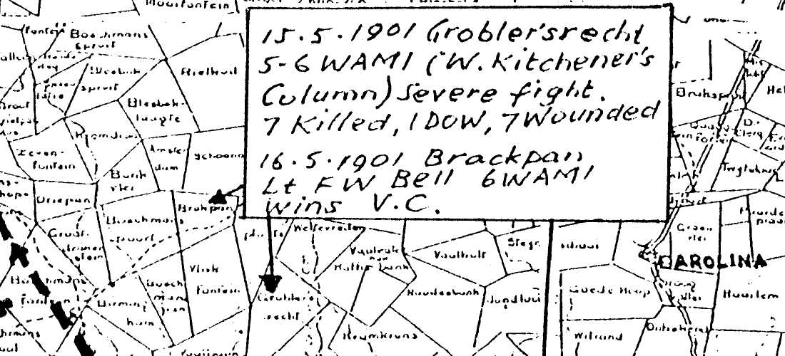
In about 1995 Rob Nelson in Perth, via John Woodgate sent a copy of a map found in Lord Forrest's papers. The map was a copy of a sketch map of the actions at Brakpan. Of the five killed on 15 May one was Lt Anthony Forrest, son of the former Lord Mayor of Perth, and a nephew of the Premier, Sir John Forrest. The news of Anthony Forrest's death may well have contributed to his father's own death soon afterwards. The sketch map shows where Lt Forrest was killed. and where Bell won his VC. The map now resides in the J S Battye Library of West Australia. The map-maker is not named but from the considerable detail included it must have been drawn by someone very familiar with the scene, probably present on both days. The map itself was about the size of four pieces of A4 paper.
In October 1997 I deposited this map, along with other
papers, in the then newly opened Empire & Commonwealth Museum in Bristol.
Later in the month I had a letter from Max Chamberlain in Australia
asking if I could supply a copy of the map - the original in the JS Battye
museum had apparently disappeared. He also supplied a draft map of his own
describing four battle sites in E Transvaal,
now called
In September 2007 I understand that Brakpan is still likely to be the name of the farm where the action took place.